Personal positioning system for tunnel environments
Introduction
Positioning systems play a central role in many industrial contexts, including process control, logistics management, or safety systems. For example, in constructions of subway tunnel, due to the existence of closed strong, communication inconvenience, harsh environment, all causes a serious threat to the construction personal safety. Whether for management measurement or for timely rescue purpose, the location of personnel is one of the most important information for tunnel security.

Underground tunnel construction
However, most traditional positioning technologies have problems for tunnel application. Take GPS for example, its accuracy is known to be very dependent on the atmospheric conditions and its use is very limited in indoor or dense urban areas, not to say its performance in underground tunnels. Blow is an overall positioning technologies according to their coverage and accuracy levels:
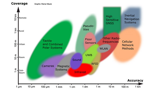
Positioning technologies according to coverage and accuracy levels
Personal positioning system
Aiming at common tunnel positioning prolbems, WiiHey proposed a personal positioning system consists of a wireless sensor network (WSN), where anchor nodes or sensors are distributed along the tunnel site to collect the signals transmitted by a RF-based target node carried by a person (usually installed on the safety helmet):
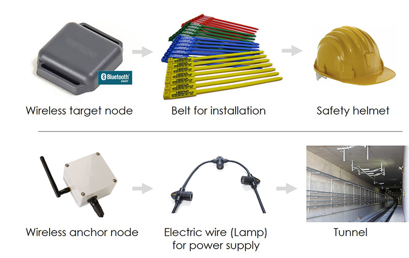
IoT devices for positioning system
Target nodes installed on safety helmet, anchor nodes installed on tunnel roof
The system has a strong positioning performance, low power consumption, small size deployment and other characteristics like real-time personal coordinate on tunnel maps.
Key features
- Tunnel localization based on RSSI fingerprint measurements;
- Wireless mesh network to achieve signal coverage for whole tunnel area;
- Target node hardware being small-sized, easy to carry, wireless and low energy;
- Integrate easily with existing equipments and operating systems;
- Real-time personal coordinate display on a GIS tunnel map;
Benefits
- Provide localization coverage in the whole tunnel area while being cost effective;
- Allow for accuracy levels capable of localizing multiple persons within a few meters;
- Can be upgraded in areas where higher accuracy levels are required, in the order of one meter;
- Help to ensure human safety on-site and assist all security and management works;
Architecture
The personal positioning system is formed by several key parts:
- Target node: installed on safety helmet, periodically sending out advertising packet containing one person's ID;
- Anchor node: installed distributedly along the tunnel site, each representing a coordinate of a specific area in the tunnel, listening to the target node's advertising packet;
- Anchor nodes (the wireless network): all the anchor nodes forming a wireless mesh network by HOHNet™ protocol to achieve good signal coverage across the tunnel and relaying signal;
- Gateway: installed at tunnel entrance where cellular signal is avaible and transmitting data to the cloud sever;
- Cloud sever: implementing positioning algrithm, coordinate mapping and data display, etc;
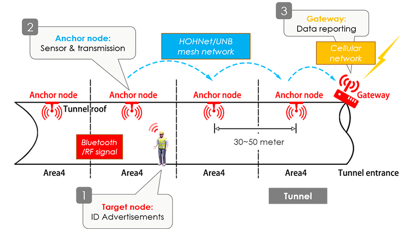
Personal positioning system architecture
RSSI fingerprinting based positioning
The RSSI is a measure of the magnitude of the signal power as assessed by the terminals of a receiver. Since the received signal’s strength decreases as the distance to the transmitter increases, the RSSI can be used to estimate distance. However, due to the environmental changes, interferences and effects of multipath, scattering and reflections, RSSI has complex variability patterns which is difficult to predict.
Location fingerprinting is an empirical method of estimating the location of a mobile target with RSSI measurements. The method involves an offline (calibration) phase and an online (location estimation) phase:
- The offline phase measures the network signal characteristics, aka the fingerprints, at certain points in order to create a map of the network. This map, called radio-map, can then be used during the online phase to infer the position of the device;
- The online phase is a procedure involving comparing the newly collected signal characteristics against those stored in the map. Pattern matching algorithm such as K-Nearest Neighbor (KNN) method will be used here to select from the radio-map the point whose norm to the online measurement is smallest, i.e., the point having the closest RSSI pattern, and choose to be the target's actual position;
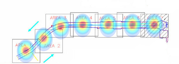
RSSI radio map
summary
Aiming at the problems of short transmission distance, multipath effect and low positioning accuracy in the common tunnel personnel positioning technologies, WiiHey proposed a new system of personnel positioning system based on RSSI fingerprints measurement. The system utilizes the advantages of technologies of wireless communication and pattern matching to achieve a reasonable position in the complex environment of a tunnel.